Dettensee / Geography / Map Of The Village
Map Of Dettensee
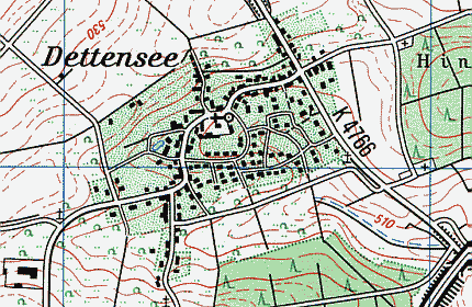
On the left, you see a map of Dettensee. If you have got a browser capable of JavaScript, and
JavaScript is also turned on, the names of the streets, roads and places are shown in the field
below when you touch them on the map with your mouse cursor.
Click on a street or building to jump down to the explanations.
Source of this picture: topographical map 1:25000 - © Landesvermessungsamt
Baden-Württemberg of April 2, 2004, Az.: 2851.2-D/3173.
Explanations
- Adam-Keller-Straße - named after Adam Keller von Schleitheim,
who was a colonel in the Imperial Army in the Thirty Years' War. For some time he was commander of the city of
Constance. He inherited the village of Dettensee from his wife Rosamunde, who had been married to Count Karl
of Hohenzollern-Haigerloch before. After some heridetary disputes, he finally became
the owner of the village by purchase on July 20, 1638.
- Brandweg - small side street of Georg-Schorpp-Straße. Named after the
estate of “Brand” (“burning”). Probably a special kind of
agriculture was performed there: the plants were burnt down regularily, agriculture was run for a while, and
then the wild plants were allowed to come back until the next fire.
- Erlenhof - from the old name “Erlenbosch” (“alder thicket”)
- Fichtenwaldstraße - named after the Spruce Fir Forest near the sports
area, where the street leads to. Called “Zinken” by the inhabitants of Dettensee.
- Fintan-Guntlin-Straße - Fintan Guntlin was the first of the governors of
Dettensee from the monastery of Muri in the 18th century.
- Gässle - literally “narrow lane”.
- Georg-Schorpp-Straße - Through road from north to south. Named after
Johann Georg Schorpp (born 1849 in Bieringen, died 1920 in Dettensee), a citizen of Dettensee, who lived
in this street. He was the donor of the old church organ and founder of the Schorpp donation.
- Großäckerweg - after the estate name of “Großäcker”.
- Herrenhaustraße - after the “Herrenhau” forest. The name
means that this area was pasture-ground one and only became a forest again later.
- Nellenburgstraße - after Christof Ladislaus count of Nellenburg (died 1591),
the builder of the Castle of Dettensee, of which the steward's house (Vogtei) remained.
- Neuneckstraße - main street of the village.
Named after the lords of Neuneck, owners of Dettensee from 1596 till 1620. Their coat of arms also influenced the
modern coat of arms of the village.
- St. Cyriakus Church - see the separate page.
- Reuteweg - small lane near the pond. The name is derived from the verb “reuten”
(southern German for “stub”): Originally the place of a clearing (by fire?).
- Schlossgartenstraße - first street of the new building places area.
Formerly the garden of the Castle of Dettensee.
- Schlosshof - literally “Castle Square” - originally the interior court
of the Castle of Dettensee.
- Tabernwasener Weg - named after the Tabernwasen estate with a farm and
a chapel near the neighbouring village of Nordstetten. Called “Bruck” by the inhabitants.
Considering the word “taberna” (Latin: “cabin”, “restaurant”, also “workshop”)
and the old Roman road passing by the estate, there was probably once a resting place on this site.
“Wasen” means “meadow”.
- Vogteigebäude (steward's house) - see the separate page.
- Wiesachweg - after the estate name of “Wiesach” south of the lane.
Last update: April 19, 2004 - www.dettensee.net
Information about the street names was provided by Herbert Zander. Publication of this data is only allowed with his permission!