Dettensee / Geography
On A Large Scale
![[Satellitenbild Europas; Lage Dettensees durch Kreuz markiert]](../../bilder/geografie/dettensee-europa.png "Satellitenbild Europas; Lage Dettensees durch Kreuz markiert") |
Dettensee is …
- 479 kilometers, 524 meters, 35 centimeters east of Greenwich (that is, 319.71 miles) - or 8°, 43', 23.731'' east longitude
- 5363 kilometers, 360 meters, 32 centimeters north of the equator (that is, 3352.53 miles) - or 48°, 25', 19.595'' north latitude
- at an elevation of between 495 and 540 meters above mean sea level (that is, between 541 and 591 yards)
|
![[Karte Deutschlands:
Hervorgehoben Baden-Württemberg, Regierungsbezirk Karlsruhe; Lage von Dettensee durch Kreuz markiert]](../../bilder/geografie/dettensee-bw.png "Karte Deutschlands: Hervorgehoben Baden-Württemberg, Regierungsbezirk Karlsruhe; Lage von Dettensee durch Kreuz markiert") |
![[Aerial view of Dettensee from Google Earth]](../../bilder/geografie/ge-ansicht.jpg "Aerial view of Dettensee from Google Earth") If
If ![[Britische Flagge]](../../bilder/nav/flagge-uk-klein.gif "englischsprachig") Google Earth is available on your computer,
you can reach us directly via kmz file.
Otherwise, please check
Google Earth is available on your computer,
you can reach us directly via kmz file.
Otherwise, please check ![[Deutsche Flagge]](../../bilder/nav/flagge-de-klein.gif "deutschsprachig") Google
Maps to see Dettensee and the region, or find your route with web.de (for all of Europe):
Google
Maps to see Dettensee and the region, or find your route with web.de (for all of Europe):
On A Small Scale
The village with its 291 hectoares (that is, 719 acres) and its some 500 inhabitants is
situated at the southerneast part of the district of Freudenstadt in the German federal state of Baden-Württemberg.
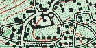 The area around Dettensee has got some small hills and several little valleys. You can find a village map with
explanations of all places and streets on these pages, too.
The area around Dettensee has got some small hills and several little valleys. You can find a village map with
explanations of all places and streets on these pages, too.
Last update: January 4, 2007 - www.dettensee.net
Sources: Satellite picture is Public Domain by NASA,
thunbnail Google Earth screenshot by Google.